Karakoram Highway Guide: The World's Greatest Mountain Road
Plan your trip
The Karakoram Highway (KKH) is one of the great road trips of the world — 1,300 km from Islamabad to Kashgar in China, climbing from 500m to 4,700m at Khunjerab Pass, passing through the confluence of the Hindu Kush, Karakoram, and Himalayas mountain ranges. The Chinese and Pakistani governments built it between 1966 and 1986, losing over 900 workers to avalanches, falling rock, and the Indus River. The result is a road that follows the ancient Silk Road through some of the most dramatic mountain scenery on earth.
For travelers, the Pakistan section (from Islamabad to the Khunjerab Pass, ~900 km) is the journey. The Hunza Valley in the middle section is the destination.
The Route
Islamabad to Besham (350 km | 6–7 hours)
The KKH begins from Rawalpindi (the older twin city adjacent to Islamabad) and immediately enters the Indus Valley at Attock. The first major section follows the Indus River north — a wide, grey-brown river cutting through increasingly arid hills. This section is the least dramatic; it’s the approach road to what comes later.
Key stop: Khanpur Dam (40 km from Islamabad): An artificial lake on the Haro River with turquoise water — used for water sports. A 30-minute detour worth making.
Besham to Chilas (200 km | 5–6 hours)
The Indus narrows, the valley walls rise, and the road begins to feel genuinely precarious. Landslides are common and the road is carved into vertical cliffsides above the river. At Chilas, the Indus gorge is at its deepest.
Nanga Parbat Views: South of Chilas, the world’s ninth-highest mountain (8,126m) appears suddenly — a massive ice face rising directly from the Indus gorge. The Rupal Face (visible from the south) is the world’s highest mountain face, rising 4,600m above its base. From the KKH, the north face (Diamir) is visible. On a clear day, this is one of the most dramatic single views in mountain travel.
Shatial Rock Carvings: Ancient Silk Road petroglyphs carved into boulders along the Indus — images of ibex, snow leopards, horses, Buddhist stupas, and traveler inscriptions in a dozen scripts. A UNESCO recognized site. Several visible groupings near the road between Shatial and Chilas.
Chilas to Gilgit (70 km | 2 hours)
Through the Gilgit River confluence — the Indus gives way to the Gilgit River here, and the valley begins to widen slightly. Gilgit is the regional capital of Gilgit-Baltistan and the practical base for exploring the northern section.
Gilgit (1,500m): A functional town with hotels, supplies, and transportation connections. The main bazaar, the Kargah Buddha (a 7th-century rock carving of a Buddha figure above the town), and the Gilgit River confluence are the main points of interest. Most travelers overnight here before continuing north.
Gilgit to Hunza (70 km | 1.5 hours)
The most spectacular section of the highway begins north of Gilgit. The Hunza River valley opens between Rakaposhi (7,788m, south side) and Ultar Sar (7,388m, north side) — both visible from the road on clear days. The valley narrows and the terraced apricot orchards of Hunza begin to appear on the hillsides.
Rakaposhi View: At the village of Minapin, a viewpoint provides one of the most photographed mountain views in Pakistan — Rakaposhi rising 6,000m above the valley floor, ice face directly above green terraces. Clear in early morning.
Hunza Valley (2,438m)
Karimabad is the main town — the former seat of the Mir of Hunza, a semi-independent state that controlled this section of the Silk Road until 1974. See the full Hunza Valley Guide for detail; this is the central destination on the KKH.
Hunza to Khunjerab Pass (200 km | 4–5 hours)
North of Hunza, the valley narrows through Gojal (Upper Hunza) and the landscape changes dramatically — alpine meadows, glaciers, and the high-altitude steppe approaching the Chinese border.
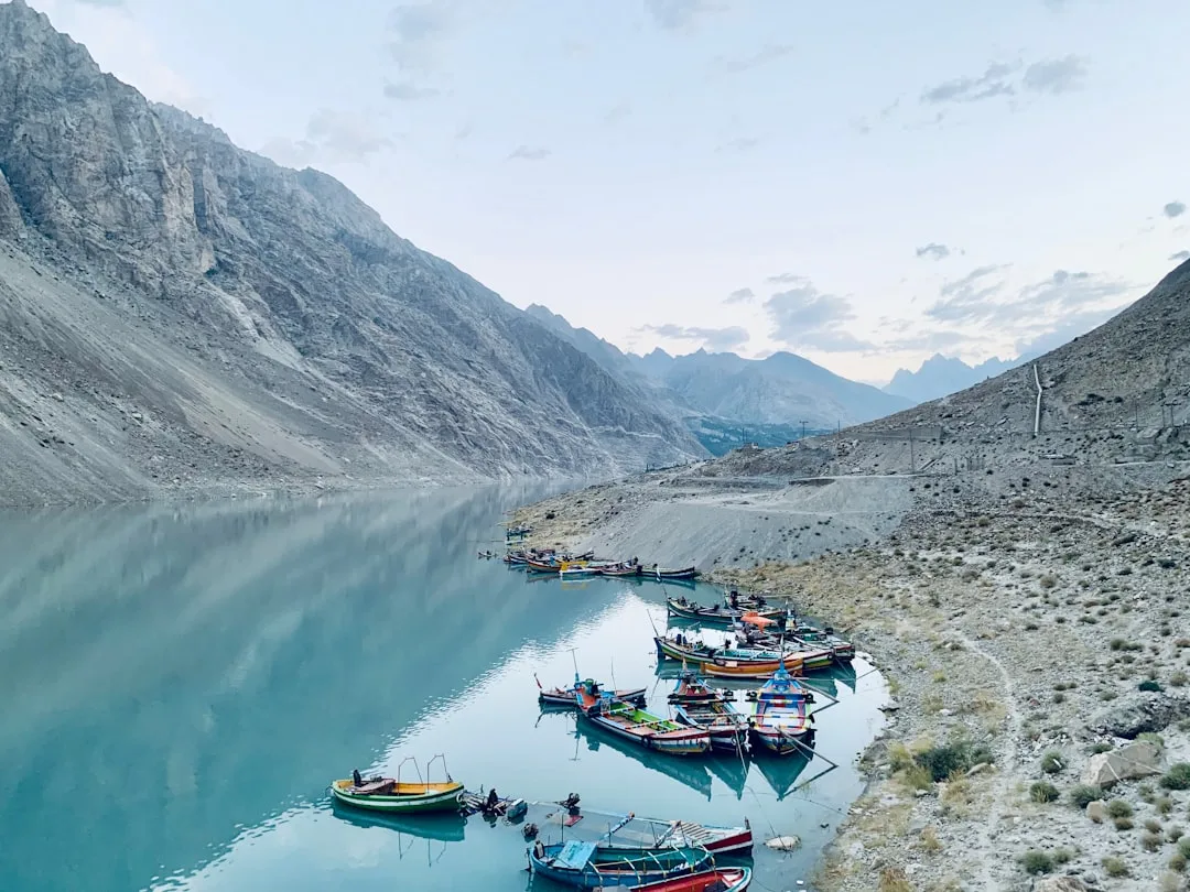
Attabad Lake: Created in 2010 when a catastrophic landslide blocked the Hunza River, drowning several villages and creating a 21 km turquoise lake. The road was rebuilt over the lake on elevated bridges (completed 2015). The lake’s color — glacial turquoise against bare brown cliffs — is extraordinary.
Sost: The last Pakistani town before the border, with customs, money exchange (last chance to exchange currency), and basic accommodation. The border crossing at Khunjerab is 90 km north.
Khunjerab Pass (4,693m): The border crossing between Pakistan and China — the highest paved international border crossing in the world. The drive from Sost is through high-altitude plateau vegetation (Marco Polo sheep are present; yaks are visible). The pass itself is a flat, windswept, treeless plateau with a monument at the border. Open May–November only (closed in winter).
Logistics
Transport Options
Private car/jeep: The most flexible option. Rentable in Islamabad or Gilgit with a driver (who also knows road conditions, landslide alerts, and local contacts). Cost: ~PKR 8,000–15,000/day with driver.
NATCO bus: The national public bus service runs Rawalpindi to Gilgit (20+ hours) and Gilgit to Sost daily. Cheap (PKR 800–2,000), slow, and comfortable enough for the experience. The overnight bus from Rawalpindi arrives at dawn in Gilgit.
Shared jeep from Gilgit: For the northern section, shared jeeps operate between Gilgit, Karimabad (Hunza), and Sost. Cheaper than private hire; depart when full.
Best Season
May–October: The road is open and the high passes are accessible. Peak season is July–September when the Hunza apricot harvest is underway (June–July, fresh fruit available everywhere) and mountain views are clearest.
April/November: Shoulder season — the road is passable but Khunjerab Pass may be closed; weather is less reliable. Excellent for avoiding crowds and lower prices.
December–March: Khunjerab closed. The Indus Valley section remains open but cold. High elevations inaccessible.
Road Conditions
The KKH is not a comfortable road. Landslides block sections seasonally; new sections are perpetually under construction; the road surface varies from excellent (recently rebuilt Chinese sections) to rough gravel (after landslides). A 4WD vehicle is recommended north of Gilgit. Check road conditions locally before departing.
Flooding and landslides: Pakistan’s northern areas are subject to glacial lake outburst floods (GLOFs) — a growing hazard as glaciers retreat due to climate change. The Attabad Lake was created this way. Check recent conditions with local operators and the PDMA (Provincial Disaster Management Authority).
Permits
Foreign travelers require a No-Objection Certificate (NOC) for certain restricted areas in Gilgit-Baltistan, particularly for trekking near the Chinese border and some high-altitude areas. Most standard KKH travel doesn’t require an NOC, but confirm with your tour operator before traveling beyond Hunza toward Khunjerab.
Why This Journey
The KKH is not easy travel. The road is long, the terrain is challenging, and the infrastructure is basic by international standards. What it provides is irreplaceable: a ground-level traverse of the world’s highest mountain ranges, through valleys where the Silk Road traders have passed for 2,000 years, between cultures that have been trading, fighting, and intermarrying since before Alexander the Great came through. The views from the road are frequently among the best mountain views on earth — raw, close, and unmediated by tourist infrastructure.
Plan your trip